Radiosonde DFM-17
- High accuracy GNSS radiosonde with PTU measurements
- Optional XDATA and NFC interfaces
- Intuitive design with LED-status indicator and easy ground check
- Powerful and highly stable transmitter with continuous frequency selection
- Optional barometric pressure sensor, XDATA interface, wireless ground check
DFM-17 is one of the most advanced and accurate radiosondes on the market, delivering daily weather data for millions of people worldwide. The industry leading performance of our sensors, including the new continuously heated humidity sensor, paired with our robust Multi-GNSS windfinding technology and the accompanying grawMet software makes this one of the most advanced systems available.
This makes our sounding systems trusted by meteorological agencies, researchers and special users alike. The eco-friendly design reduces the amount of resources used for the electronics as well as the primary plastics content.
Pilotsonde PS-15

- Optimal for applications where only wind finding is required
- Accurate and reliable Multi-GNSS technology
- Easy-to-Use design with informative LEDs and seamless ground check
- Powerful and highly stable transmitter compliant with ETSI EN 302 054
- optional barometric pressure sensor and XDATA interface for add-on sensors
The Graw PS-15 pilotsonde is the right choice if an application requires no temperature and humidity data. All of our radiosondes use the same groundstation equipment and reliable grawMet software. Therefore, the decision between radiosonde and pilotsonde can be made on an ascent-by-ascent basis, which is key for value-oriented customers.
Our PS-15 uses the same accurate and reliable Multi-GNSS technology as the DFM-17 and can replace conventional pilot balloon ascents which require manual tracking. It can even be equipped with a barometric pressure sensor as well as an XDATA interface to accompany external sensor payloads.
GS-I

- Redundant ethernet connection for highly reliable network integration
- Proven receiver technology with embedded PC for data pre-processing
- Sounding data can be processed on multiple independent workstations
- Software defined radio and antenna diversity for optimal range
- Inbuilt GNSS receiver and re-radiator streamlines launch preparation
GS-I is the heart of a highly innovative sounding system concept to accommodate the needs of institutional users who need to get the most out of their system. The sounding system can be installed miles away both from the launch site and the data processing facility.
The sounding data is transmitted to one or multiple independent workstations, enabling redundancy and varied data processing, while also allowing for the integration of raw data streams with the user's real-time processing systems. Radiosondes can be initialised before flight to be available for every workstation in the network
GS-E

- Completely maintenance-free (without air filter)
- Ideal for office applications
- Software defined radio and antenna diversity for optimal range
- Inbuilt GNSS receiver and re-radiator for streamlining launch preparation
- Industry standard USB interface to attached sounding workstation
GS-E is a general-purpose sounding system designed for office environments and is used by hundreds of synoptic launch sites worldwide. Robust Software defined radio (SDR) technology and automatic antenna switching ensure no data gets lost. RF cables from the antennas are attached to the sounding system, which itself connects to a sounding workstation (PC) running grawMet software.
The maintenance-free design with no moving parts ensures smooth operations. An integrated GNSS receiver and re-radiator streamlines launch preparations.
GS-B

- IP65 ingress protection for harsh ambient conditions
- Environmental protection conforms to MIL-STD-810
- Robust enclosure and integrated ruggedized mobile workstation
- Software defined radio and antenna diversity for optimal range
- Inbuilt GNSS receiver and re-radiator streamlines launch preparation
GS-B offers an uncompromising solution enabling users to perform soundings at any location and even under adverse environmental conditions. The field-proven pelicase houses the robust mobile workstation alongside the sounding system, offering a truly all-in-one mobile experience.
Two antenna channels, a ground weather station connection and an integrated GNSS receiver and re-radiator allow the GS-B to be set up in a sheltered location. The highly customisable grawMet software guides the sounding and allows creation of all standard WMO reports and STANAG messages.
MultiSonde System

- Simultaneous data reception from multiple radiosondes
- Scalability due to modular system architecture
- Redundant ethernet connections for high-reliability network integration
- Sounding data can be processed on multiple independent workstations
- Proven receiver technology with integrated embedded data pre-processor
The multiSonde racks are designed for users that require the ability to simultaneously receive data from multiple radiosondes in mission-critical environments. Standard configurations are 4 or 8 sounding channels as mobile or desktop installations and the system can be adapted for 2-16 sounding channels.
The multiSonde racks can be installed an unlimited distance away from launch site and sounding workstation. Sounding data is sent to one or multiple independent sounding workstations, allowing for redundancy and user specific data processing, as well as integrating raw data streams with the users own real-time processing systems.
Freely Programmable Frequency
Each Radiosondes can transmit in a narrow channel anywhere within the meteorological band (400 to 406 MHz). The sonde uses an on-board frequency synthesiser, which is automatically set to the desired transmission channel during initialisation.
The highly-sensitive ground station receiver system does not require a steered antenna and can receive valid data from sondes up to 300 km slant range using its compact dual antenna set.
Overview
The main function of the Ground station is receiving the Radiosondes signal and providing local GPS information. All functions are software-controlled by a standard Windows PC / Ruggedized Notebook via USB.
SDR (Software Defined Receiver)
Antenna Switch (Diversity)
GPS Module.
Software
Meteorological Messages (WMO)
Antenna System
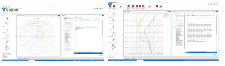
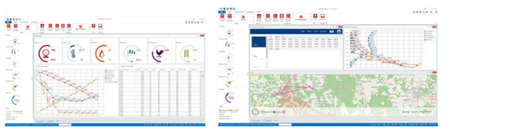
GRAWMET Software

Switch on, plug in and go
It has never been easier and faster to initialise a radiosonde and to make it ready for take off. No redundant clicks. No time-consuming preparation. You can concentrate purely on the analysis and evaluation of the data. The sounding is detected automatically. You are automatically provided with the graphical and tabular views that are relevant for you. Following sounding there’s no need to worry about the transfer of your results. GRAWMET takes care of this for you
The system generates WMO and STANAG weather messages as well as various graphical and tabulated evaluations. The software uses the common windows style graphical user interface (GUI) making it easy to work with. Data from the radiosonde is received by the groundstation for further processing by GRAWMET.
GrawMet
- Intuitive user interface with graphical and tabular data views
- Database-driven evaluation of meteorological measurement data
- Regular quality updates provided
- Individually adjustable user interface
- Status notifications and visualisation of current sounding data
- grawMet is our database-driven meteorological software for analysing daily radiosonde measurements. It allows you to keep an eye on the status of your sounding and your current sounding data at all times.
GrawMet is the ultimate software solution for managing and evaluating daily radiosonde measurements and offers extensive functions for smooth operation. With its user-friendly interface, grawMet provides a clear and intuitive overview of the status of your soundings and current measurement data. The real-time status bar or the software’s pop-up windows ensure that you are always informed about the ascent process.
Whether you need to analyse measurement data, review weather messages, or monitor the quality of data reception, grawMet delivers everything you need for efficient and precise radiosonde data management.
Automatic Creation of Weather Messages
The program computes and automatically generates standardised current weather messages upon reaching the specific altitude limit. Optionally, the user can change the altitude limits. Provisional computation of weather messages before the set altitude limits are reached is also possible. For greater clarity, all messages computed are presented in the status tree.
Generated Messages (Extract)
.jpg)
These weather messages are displayed on the screen in tabulated form and can be filed for future reference. During the ascent, all data of the weather message can be viewed by scrolling. The message headings and body of the message can be later edited in order to supplement messages, if incomplete.
Weather Indices
GRAWMET creates the following weather indices automatically: LFC, LCL, CCL, Showalter Index, CAPE, CINH, EL-Equilibrium Level, K-Index, Total Index, KO Index.
Graphic Data Processing
Various parameters can be displayed and printed in the form of different graphical presentations: Thermodynamic Diagram, Tephigram, T-Log (P) Diagram, Emagram, Hodograph, Altitude Diagram, Refractive Index, etc.
Multiple Languages
The system is designed as a multiple language system. Apart from the main languages (English, German, French, Spanish), several other languages are available. Please contact us!
Google-Earth Support
The flight-path of the radiosonde can also be monitored by Google-Earth.
GRAWgo cloud-based analyses
Watch your upper air sounding stations – from anywhere at any time
GRAWgo is the latest cloud-based solution to monitor your upper air sounding stations. Access your stations from anywhere at any time. GRAWgo allows you to always keep an eye on the status of your sounding and your current sounding data of all stations. Features like the overview of current events and push notifications (start and balloon burst detection, error detection), measurement and receiver data, status of weather messages, charts, quality of data reception, flight track view, etc. make this App the perfect companion for mobile monitoring. A further and great application possibility of GRAWgo is the local status monitoring during the ascent preparation, since you get all necessary status information during preparation and during the ascent start directly on-site. The App-based application is intuitive and easy to use and it is available for iOS and Android smartphones.
Balloon Filling Unit SO-2
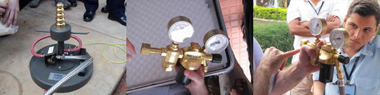
This unit facilitates the filling and preparation of the balloons:
The neck of the balloon is put over the nozzle of the SO-2 which is connected to a gas (helium or hydrogen) cylinder or storage tank. Weights are put on the arms of the SO-2 depending on the requested free lift. The filling of the balloon is automatically stopped once the desired free lift is reached and the balloon may then be tied to the Radiosondes. The SO-2 can be used for balloons 200 grams and larger. For smaller balloons other suitable units are available.